Trip to Weymouth & Book Research
- Mikey Owen
- Jan 25, 2024
- 17 min read

Updated: Feb 22, 2024
In December of 2022; I decided to take a trip to Weymouth with my Dad to obtain some research material to help influence my final animation. As my project would be taking place in the same town, albeit 700 years prior, I was hoping I'd be able to find information about the layout of the town during that time period, what life was like for it's citizens, what they wore, tools they used etc. At least that was my hope anyway!
Landscape:
I began my research by studying the coastline and landscapes of the town as this would dominate the background of my shots, and wouldn't have really changed much in the last 700 years (aside from obvious retreat due to erosion). I've compiled the shots I took of the coastline and surrounding landscapes below:


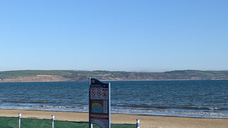


I appreciate I may not be able to take a lot from these images, as there's nothing really distinctive about the look of the landscape. I feel like if I were to shape the hills in the background of my animation to match the exact shape of the coast, that would be a lot of effort for a detail which only I would notice.
I can however, use their look and materials as influence rather than their shape. For example, the vast majority of the rocks which make up the coastline of Weymouth are the same as those across the Jurassic coast: sedimentary rocks, such as limestone and sandstone. I can therefore ensure I either locate or create materials which match the look of these rocks for my scene to add another layer of location accuracy to my animation.
Additionally, while the majority of the surrounding land has been flattened out due to farming and separation into fields, the plants visible in some of the images are likely the same types as those which would have dominated the open spaces at the time. Plus, farming isn't a purely modern convention, so I could feasibly include flattened fields in the landscape of my animation.
The Town:
With research obtained for the general look and layout of the surrounding scenery, I could now focus my attention on the town itself. Of course the layout of the town will be completely different from how it looked 700 years prior, there were certain details worth photographing which I'll discuss below the image gallery:


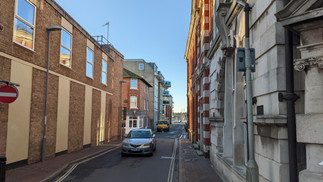


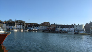


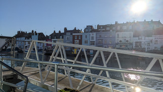


I had an in-depth discussion with the ladies who operated the Weymouth museum (https://www.weymouthmuseum.org.uk for your reference) who informed that, yes the buildings obviously wouldn't be as numerous or modern 700 years go, the general layout of the streets has not changed as much as you'd think! The narrow alleyways, location of the docks (and in particular the stone at the edge of the water) are staples from when the town was founded.
I therefore took as many photos as I could of the docks, stonework, alleyways and main roads close to the museum. With these images in hand, I believe I'll now be able to produce a far more historically accurate medieval town by using these as a reference for street layouts, as well as the location of the dock (and stone work used to indicate it).
The Museum:
As I mentioned in the above section; I took a trip to the Weymouth museum during my visit. Unfortunately at the time of my visit, it had been turned into a small pop-up due to the main building needing repairs. However, the individuals running this pop-up were still incredibly knowledgeable about their town and it's vivid history, and were more than happy to provide as much information as they could about Weymouth in the 1300s. I've compiled a gallery below of the images I took from the small exhibit to help with my project:


Unfortunately it's worth noting that a few of the exhibits were actually only relevant to me to indicate what I should not include in my 1300s depiction of Weymouth. For example, the bridge linking the two ports was actually built in the mid 1600s, so prior to this the estuary actually separated the two ports.
I was lucky enough though to discover the examples of medieval fishing tools, which would have been littered all over the docks of a 1300s Weymouth. These will make great references for modelling props for my animation! You'll also note that there was an entire panel on the middle ages, which detailed Edward III's visit to Weymouth a few years prior to the outbreak, and also includes an illustration of medieval ships! Once again this information will be so important for obtaining historical accuracy - I'll be able to model accurate ships for the dock, as well as also provide some environmental storytelling by evidencing the king's visit to the town (perhaps through background character discussions? posters?).
Additional Research:
One of the curators provided me with the email address of an architect associated with Kings College in London, who also happens to be an expert in middle ages Dorset. I've contacted him requesting whatever information he can give me to assist with my project, and received the following email as a response:

I'll admit the initial few lines of the response are disappointing (and confirm taking an additional trip to Weymouth, to view the museum in it's proper building, would be a waste), he does provide a lot of useful information further in! I was already aware of the separation of the towns, as well as how the disease entered the county, but I didn't realize that it actually entered at the port of Melcombe Regis which is on the opposite side of the River Wey to the main bulk of Weymouth.
Additionally, the maps he attached to the email shine some additional light on the layout and general shape of the respective towns, which will go a long way to injecting some more accuracy in my 3D recreation of them. I've included the maps below for your reference:


Lastly, you'll also note that he provides two book recommendations in the email. I've researched the content of these books, and even found a few exerts from 'Weymouth - An Illustrated History' online, and have to concur that these would be extremely beneficial to my research! I've obtained a copy of each, and will post an analysis on passages that I will use to enhance the accuracy of my project below.
Medieval Weymouth: Growth & Decline (by James Crump):

This book, by definition of it's own blurb, covers the histories of the twin towns Weymouth & Melcombe Regis from the eleventh century through to the sixteenth. Given that I need to know as much about Melcombe Regis in the mid 13th century as possible; this should be ideal!
I've read through the book in it's entirety, and while the majority of the information it contains is unfortunately irrelevant to the specific time period I'm focused on, there are absolutely some valuable passages that I can use to influence my animation. I felt the best way to highlight these passages, was to quite literally highlight them in the book. From there I've decided to list them all below, along with a brief explanation on how each passage will influence my project:
"-the great medieval trades of wool and wine provided the basis of their economic life." - Introduction, page 1 - This refers to the main imports/exports of the town. I can use this information to ensure that all the produce visible on the dockyard & ships at the beginning of my project contain wool and/or wine for some additional accuracy.
"Melcombe was somewhat unusual in that it was also deliberately planned with a more sophisticated grid layout." - Introduction, page 1 - This is great to know because, whilst I'm not sure how much of the town's layout will really be seen, if I do include it in the back or foreground of shots I can ensure to stick a rudimentary grid layout for the streets.
"-the only direct means of crossing between them had been by a rope ferry." - Origins, page 3 - My previous research on the towns revealed that the bridge connecting them wasn't build until much later in their history, but it's interesting to know that prior to that they had a simple rope ferry. It would be great to include this for some additional accuracy, even if only in the background.
"-at least of these parcels of land is described as being on the northern side of Bakerestrete, implying that the street ran east to west." - The Charters, page 17 - Not only does this passage give us a street name that was used during the right time period, it also gives us the orientation. This is great information, even if it's only to label a street sign.
"-St. Edmund Street and the town ditch-" - The Charters, page 17 - Another street name that I can use in my project, as well as mention of the town ditch which was used to separate the 'commoners' and merchant districts.
"-a weekly market on Monday-" - The Charters, page 17 - A simple addition, but one which could add some scene dressing to my project. I know I want a section to take place in the town market, and I could now have this take place on a Monday to highlight how surprising it would be to have that space be empty?
"-there were distinct differences in status between the boroughs of Weymouth and Melcombe." - The Charters, page 18 - Something I was unaware of in my previous research was the economic disparities between the two towns which caused a lot of resentment. Perhaps this is something I could show in my animation in some way, with Melcombe being more profitable and 'clean' compared to Weymouth.
"They give a picture of the town which had changed little since the middle ages..." - Planned Medieval Towns, page 21 - A small detail, but it's encouraging to know that my research into the layout of the modern day town can still be somewhat used as the layout remains roughly the same (although obviously much larger).
"contains but one narrow and irregular street, near a mile in length, which runs east and west and another that runs north to south to the Look Out. The houses are of stone and tiled; but generally low and indifferent." - Originally from John Hutchins' History of Dorset - Planned Medieval Towns, page 21 - This is a wonderful passage to find for two reasons: firstly, even though my animation takes place in Melcombe and not Weymouth, to have a layout of the main street of the town in the background will be brilliant for immediately establishing (to anyone with knowledge of the towns) which one my animation takes place in. Secondly, because it gives us a rough idea of the materials used and sizes of the houses in the town! An overlooked but crucial detail.
"It has two streets, broad and well paved, which terminate in a spacious market place. Many of the houses are Large and high, though in general low, as are most of the buildings in this county near the sea and are of stone and tiled. Here are also many houses and yards for wares" - Originally from John Hutchins' History of Dorset - Planned Medieval Towns, page 22 - A simple passage, this time discussing the layout and building materials used for Melcombe. It's good to know that there are far more buildings in Melcombe, with some being far higher than those in the opposing town, but the materials remaining mostly the same.
"Weymouth as nowe it is, but little, consisting chiefelie of one streete, which for a good space lyeth open to the Sea, and on the back of it riseth an hill of such steepnesse that they are forced to climbe up to their chappell by sixty steppes of stone." - Originally from John Hutchins' History of Dorset - Planned Medieval Towns, page 22 - Again, even though my animation wont take place in Weymouth, it will surely be visible in the background. This passage gives an additional detail of how there is a chapel on the top of a large hill behind the town. This is a feature which would be great to have in the background of my shots!
"In Melcombe the original nucleus of the town was probably in the south western corner of the present town site at the end of St. Nicholas Street. The southern end of this street and Lower St. Edmund Street, which follows a line markedly different from the present-day course of St. Edmund Street suggests a simple configuration of the town, located on the early quayside here. The ferry or 'trajectus... by bote and rope, bent over the haven, so that yn the ferry bote they use no ores' described by Leland also linked Weymouth with Melcombe at the end of St. Nicholas Street." - Planned Medieval Towns, page 23, includes a cited passage from John Leland's Itinerary - This passage gives a much more detailed outline of the town of Melcombe in the middle ages, including the location of the rope ferry mentioned in an earlier passage. This section alone will be huge for creating a historically accurate layout for my town!
"-Melcombe is that it has two parallel principal streets, St. Thomas Street and St. Mary Street - The two main streets were crossed at right angles by two others, St. Edmund Street and another (probably Bakerestrete - At the southern end lay the spacious market place" - Planned Medieval Towns, page 24 & 25 - This is a combination of three passages which detail the names of all 4 of the main streets (or stretes) in medieval Melcombe, as well as the location of the market place where one of my scenes will take place. With this passage and those above it, I am one step closer to creating a historically accurate layout of medieval Melcombe.
"It is clear that they used the standard medieval perch of 16ft. 6ins. as their unit of measurement - The two plots mentioned in St. Edmund Street and the three mentioned in 'Bakerstrete' were two perches wide and had lengths of two, three, five and ten perches. The one described as being on the west side of St. Thomas Street and that lying between St. Thomas Street and St. Mary Street were each three perches wide and four perches long, (half the width of the central block)." - Planned Medieval Towns, page 26 - As well as the street names, we now have a unit of measurement and the rough sizes of the plots along them! Yet another step closer to an accurate layout.
"Market places were normally where disciplinary functions such as pillories, stocks and frequently prisons were located. If a borough had a town hall it was often to be found here." - Planned Medieval Towns, page 30 - This passage is really useful for giving me some ideas on what I could use as additional 'set dressing' for my town's market place scene. Some rudimentary stocks, a town hall, maybe even some small prison cells etc.
"The impression that emerges is of two small ports dominated by a very few rich merchants." - Thirteenth and Fourteenth Centuries, page 35 - A small detail, but worth noting to perhaps assist with some environmental storytelling in my animation. I'd like to find a way to establish some kind of economical hierarchy within the town, a clear difference in districts etc.
"-there used to be... 18 large ships and 6 barges fit for merchandise and there were 40 boats for fishing- in 1346, when Weymouth (and Melcombe) sent either 15 ships and 264 men, or, according to other sources, 20 ships and the same number of men." - Thirteenth and Fourteenth Centuries, page 35 & 37 - This is a great find because, by using these two passages within the book, I know roughly how many ships would have been docked in the port. This will be an easy and, contrary to the other examples, foreground method for displaying a level of accuracy.
"-it was broad-beamed and high-sided giving the hull a rounded shape.- its high freeboard made it easy to adapt for war by adding 'castles' fore and aft and also a 'top castle'- rigged with a single mast midships and a square sail- cogs were the main cargo vessels-" - Thirteenth and Fourteenth Centuries, page 36 - This is a collection of passages that describe the main characteristics of a 'cog', which, as the text states, were the main cargo vessels. This will be hugely valuable for creating models of my own ships to populate the port of Melcombe.
"The only depiction of a medieval ship which can definitely be associated with Melcombe, on the borough seal of c. 1285, is probably one of these.- a banana-shaped hull, a single mast, a rudder on the larboard quarter and no end posts." - Thirteenth and Fourteenth Centuries, page 36 - This passage describes another large vessel known as a 'hulk', and also provides conclusive evidence that this ship can be associated with the town of Melcombe. I'd say it's therefore safe to assume that the 18 large ships (or at least the majority of them) were hulks.
"-barges were oared ships which often also had masts.- They ranged from 20 to 50 tons and possibly larger." - Thirteenth and Fourteenth Centuries, page 36 & 37 - A short passage which gives a brief description of barges, which of course comprise the '6 barges fit for merchandise' mentioned in the earlier passage. Admittedly this doesn't provide a lot to go on in terms of modelling them, but it at least points me in the right direction.
"The Franciscans believed that the plague was brought to Melcombe by two ships, one of them a Bristol vessel, on board which were sailors from Gascony who were infected with the disease, which had been rampant in Bordeaux. Once it had arrived it rapidly spread to the inhabitants of the town." - War, Disease and Decline, page 39 - I was of course aware of the arrival of the plague on a ship from Gascony, but didn't know these additional specifics, such as it being in fact brought by two ships with one of them being a Bristol vessel. This should add just that bit more accuracy to my opening scene!
"It took two forms, depending on the mode of infection,- When it was transmitted by infected fleas the result was the emergence of dark swellings (buboes) in the lymph nodes, usually of the groin, armpits and neck, after which the bacilli invaded other major organs, especially the lungs and spleen.- This type was bubonic plague.- Person-to-person transmission occurred through the inhalation of plague bacilli from droplets of the sputum of an already infected individual. This was followed by coughing, breathing difficulties and eventual heart failure. This was pneumonic plague,-" - War, Disease and Decline, page 40 - I was already aware of the two different types of plague from my initial research, but it's great to have a literary account of the symptoms and differences. Hopefully I can apply this to my characters to show a mix of plague types among them.
"First there was the terror caused by the approach of the disease, with people fleeing who could. Then they record the torment of its symptoms and the disgust at its aftermath with the sick and dying being abandoned by their families and the dead left unburied.- plague cemeteries were set up in fields where corpses were thrown into mass graves. Crops were left unharvested and stock unchecked,- many animals were dying from a simultaneous outbreak of murrain." - War, Disease and Decline, page 41 - This is great information to assist with some environmental storytelling. The plague cemeteries set up in fields, dead animals present (even if due to the affliction of a different illness) and unharvested crops was something I always planned to improve as set dressing, but it's fantastic to find a literary link to justify this now!
As you can see from the multitude of points above, this book has been wonderful for providing me with plenty of research to influence my final project with! I'm really excited to begin applying what I've learned, but first I still have one more book to dive into which will hopefully expand my research even further.
Weymouth, An Illustrated History (by Maureen Attwooll and Jack West):

The second and final book name dropped by my contact is Weymouth, an illustrated history, coincidentally co authored by one of the curators I met and her husband! It's a much more broad book in terms of the periods of history it covers than the previous one, but still contains some great research material that I'm sure will enrich the authenticity of my final animation to no end. As I mentioned, it covers a much more broad history of the town/s, so unfortunately only a brief portion of the book is relevant to me. However, I've still collected scans of 8 useful images from the early chapters of the book, and have posted these below along with a brief description on how they can benefit my project:

You may recognise the above temple from my photos collected during my trip to the Weymouth museum, but I've included this scan due to it being much clearer in the book. I discovered during my research of the previous book that there was a roman temple visible on the hills between the town, and whilst I imagine it would have fallen into a state of disrepair in the 14th century, I imagine it still would have been visible to some degree. I'm hoping I can use this sketch to try and recreate a ruined version of the structure to place in the background of my establishing shots.

The above seal was also mentioned during my research of the previous book. You may recall a passage about the 'hulk' ship design, stating how it can be related to Melcombe due to it's appearance on the town seal; this is that same seal. I'm hoping I can use this image as a base for the design of the larger ships in my scene, and also to recreate as a decal to place on letters, notice boards etc around the town. This should hopefully add some additional authenticity to my scene.

This is a great find, a drawing from the early 20th century of the mother church of Melcombe which has remained the same since it was built towards the end of the 13th century. I already know where such a church would be located within the town thanks to the descriptions in the previous book (and maps included below), and with this drawing I should be able to recreate it in a 3D space to add some more accuracy to my depiction of medieval Melcombe.

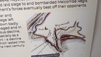
You may recognize this map as one of the two provided by my contact along with his email. I've included the scan here as some details (such as the street names) are much more visible than those in the previous attachment, plus I'd like to discuss it's uses now that I have a clearer version. Given it's the earliest available map of the towns, it's absolutely going to be my go-to reference when recreating the town. Secondly, while I'm aware of some of the street names from my previous research, having the blanks now filled in, along with the location of the church discussed above, is such a huge assistance!

As I discovered during my previous research, there were plenty of burial sites for plague victims across the fields surrounding the town, but a lot pointed to Clark's Hill as being the location of the largest. It's great to find this map which pin points the rough location of this burial site. I plan to either have this be visible in the far distance of my establishing shots, or perhaps the final shot of my animation (the house of the victim) could be located near Clark's Hill as a way to bring this location into the narrative? It's also interesting to note the differences in the shape of the land from the previous map. I'd imagine this is mainly due to erosion and the reclamation of the land by the sea & back water.
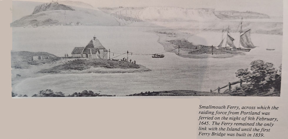
This drawing from the mid 17th century shows the rope ferry from Melcombe to the neighboring island, and whilst I doubt this specific one will be included within my animation, I will be including the one which originally connected the towns together! I think it's a fairly safe bet that that ferry would have been of a similar design to this drawing. While this drawing doesn't show a ton of detail, it's a great starting point for me to nail down an accurate design for my own recreation of it.

While I appreciate this drawing itself will be of little use to me during my project, it's actually the accompanying text that I'm interested in. It states about the renaming of a main road, St. Nicholas Street to Chapelhay Street. It also then states that St. Nicholas Street itself was also a new name for the road which was originally called Francis Street on old maps. I've included this here to ensure that I name this road 'Francis Street' (or Francis Streete as it would be spelled) in my recreation of the town.

My final exert from this book is yet another map of the two towns. Now whilst it's from much more recent history than the others, which you'd think would be counter productive, the text description lists it as 'the earliest map of the town which can be considered as accurate'. Given that the whole point of my research was to make my recreations of the town/s as accurate as possible; I'd be missing out on some invaluable reference material if I didn't include this map. Of course the size of the towns is far grander here than they would have been in the 14th century, it's mainly the plot sizes & road locations which I'm interested in, as these will have changed very little since medieval times (which I know from previous passages).
There we have it! That's all I was able to ascertain from this wonderful book, and believe it should be more than sufficient to begin the creation of an accurate recreation of the medieval towns of Weymouth & Melcombe Regis. I'm really excited to begin work on my locations and truly get my final project underway!


Comments